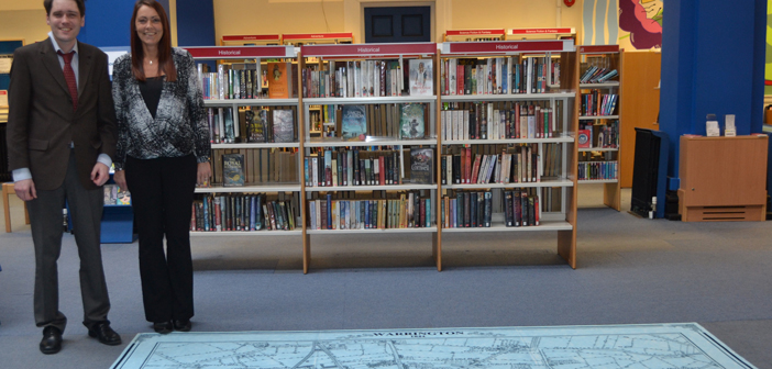
A GLIMPSE of Warrington’s historic past can now be seen beneath library users’ feet – thanks to a new large floor map installed by LiveWire and Culture Warrington.
The new map – made of specially printed carpet tiles – measure three meters by three meters and can be seen in the main atrium of Warrington Library.
It is a replicate of an 1844 map that is held in the archives at Warrington Museum and Library, one of a number of fascinating historical maps kept in the Searchroom.
Philip Jeffs, Archives Officer at Culture Warrington, said: “The map dates to 1844 and is produced from the Ordnance Survey ‘six inch to the mile’ map series.
“Every road, railway, field, fence, wall, stream and building is shown, and even smaller features such as post boxes, bollards on quaysides, mile posts, and flag-staffs.
“Some aspects of the map were simplified to make it easier to view at the time – separate buildings in a row were blocked together and temporary or ‘insignificant’ buildings were omitted, but many notable buildings are named and distinguished, including many public houses and factories.
“The original of this map and many others, both earlier and later can be seen in the Local History Searchroom at Warrington Museum and Library. All of our maps are available to the public for them to look at for research or enjoyment.”
Some familiar features or points of interest included on the map include:
* St Elphin’s Church.
* The crossroads at Market Gate.
* Bank Hall – now the Town Hall – has a view across fields and meadows down to the River Mersey.
* Where the Museum & Library now stands was private gardens for the towns’ ‘well-to-do’.
* Orford Lane and Marsh House Lane only have the odd cottage and farm on them.
* The first signs of industry appearing, such as Cockhedge Cotton Mill, Mersey Tannery and Bewsey Foundry.
* All around the outskirts of the town are brickfields, where clay is being dug and bricks being made for the vast areas of new terraced housing and factories that will be a feature of Victorian Warrington.
* Nods to historical 1840s events can be seen, such as Waterloo Place and Wellington Place at Wilderspool.
Emma Hutchinson, managing director of LiveWire and Culture Warrington, said: “We are always searching for new ways to encourage people to visit the Museum and Library and are thrilled with this engaging new addition. We hope it offers a fun and interactive way for people to learn more about our town’s fascinating history. Why not come and have a closer look – perhaps you can spot your part of town from 1844!”
The original map and others can be viewed in the Searchroom at Warrington Museum & Library.
For more information on Warrington Library and Museum please visit www.livewirewarrington.co.uk or www.culturewarrington.org
Town’s history can be seen – under your feet!
00 Comments
Share.


