

WARRINGTON Borough Council transport chiefs have announced the recommended route for the controversial Warrington Western Link road.
The council’s Transport for Warrington team has decided, after four weeks of consultation, to recommend a revised Red Route.
Further consultation on the recommended route will now take place.
Transport chiefs say they believe the Red Route will provided the best solution to achieve the objectives of the project.
But they stress that in response to feedback from the public there has been a substantial re-design of the route, which will now impact on fewer properties than originally expected.
One building which will have to make way for the project is the attractive, century-old Sloop Inn, in Old Liverpool Road.
Eight houses – four of which are unoccupied – would be affected as well as a number of business premises are also affected.
The route links the A56 Chester Road with the A57 in Great Sankey and is expected to deliver much needed congestion relief for Warrington town centre. This route would provide a new high level crossing over the Manchester Ship Canal, reducing inconvenience caused by the existing swing bridges.
Local residents along the proposed route are being informed of this recommendation via letter and the proposed route will be the subject of a further round of public consultation, starting immediately.
Details of the recommended route are available on the council’s website, along with an online feedback form. In addition, three public events are being held to enable the community to find out more about the recommended route and discuss this directly with members of the project team. The events are being held as follows:
Saturday September 23, 10am – 5pm
St. Werburgh’s Community Centre, Boswell Avenue, WA4 6DQ
Sunday September 24, 10am – 5pm
The Peace Centre, Peace Drive, WA5 1HQ
Monday September 25, 9am – 5pm
Golden Square Shopping Centre, Sankey Street, WA1 1TD
Council chief executive, Professor Steven Broomhead, said: “The revised red route is being recommended because this option best matches the stated aims of the project. Since the consultation events in July, significant work has gone into analysing the merits of each of the six routes being considered. It is also worth noting that of the six possible route options for the road put to public consultation in July, the Red route was clearly the preferred option. The project team has been able to take on board feedback from the public consultation, identifying opportunities to reduce the impact on neighbourhoods and individual properties.
“Understandably, the potential loss of people’s homes through compulsory purchase has been a major concern. It’s regrettable that we cannot avoid this to build the scheme but I am pleased that we have been able to refine our plans and reduce the number of occupied houses needed.
“Before formally recommending this route to the executive board, we are seeking community views on the details of the revised red route. This can be done online through the council’s website or at one of the consultation events being held. Following this, officers will make their final recommendation to members for a decision in November.”
Council leader Terry O’Neill said: “The proposed new Warrington Western Link is an important project for the future of the town and I would like to thank everybody who participated in the public consultation in July.
“Officers have made a recommendation for the route and would like to share that with the public before the executive board makes a final decision. It is important that residents who live locally and all those who rely on Warrington’s transport network, including businesses, take this opportunity to comment on a major infrastructure project such as this.”
The consultation runs until Monday October 2. Residents and businesses can view the proposals and comment on line at warrington.gov.uk/westernlink or they can attend one of the three advertised consultation events. Recommended route summary documents will also be available at local libraries.
If the project is approved by the executive board, the business case will be presented to the Department for Transport in December 2017.
If the bid is successful, it is expected that construction could begin on the road in the early 2020s.
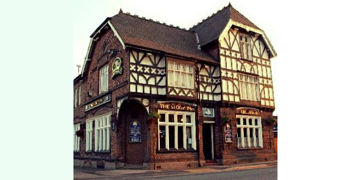
The Sloop Inn


8 Comments
No real surprises then – the route witht he least impact and costs – but I am sure there will be plenty of people seeing red with it – especially those businesses which will be impacted.
The roundabout on the southern side of the canal identified by the tag “Junction for link to future development” is of prime importance. It’s not shown in your version of the route here Gary but it is on the “revised red route” drawing. It is certainly more important than easing congestion, because that roundabout is intended to open up the ‘area of underused riverside frontage’ for ahem future development right where the “congestion solving” bridge/route is located. At the last count some 500 plus houses were earmarked for this future development. Wonder how many will be classed as “affordable”? Or will the developer be invited to contribute to WBC’s affordable housing kitty for building them “elsewhere?”
Are the revised red route route plans available for viewing online? I can’t find them. All routes impacted on the area nearest to me though as Chester Road was the start of them all. Got to feel a bit sorry for all the residents living right near there as they were in a no win situation.
I was actually expecting the Yellow route to be chosen but I can’t say I’m surprised that the Red one has been though as someone was telling me the other day that a lot of the land/businesses on Old Liverpool Road had been bought up some years back but then sold again and bought by ‘unknown’ for way way more than market value even to the extent that that the owners were a tad confused and shocked about just how much they got for it. How strange…..or not 😉
My comments were based on a map/drawing available on the WBC website Dizzy. That illustration was headed “Recommended Route – Revised Red Option” or words to that effect.
Like so many of our heritage buildings the Sloop Inn will only existing in nostalgic memories, sepia photos in the newly configured Culture “Hub” (ugh) and if we are lucky perhaps a blue plaque on one abutment of the “congestion relieving bridge” (that remains to be proven)
Thanks, I’ll have another search as I must have missed it. I might go and take some pics of the Sloop before it’s too late 🙁
A slight after thought….but doesn’t the Sloop Inn date back to the early/mid 1800’s? Is it a listed building? Shame it’s going to be demolished and another piece of Warrington heritage and history is set to be lost. It’s a lovely character building from the outside and reminds me of the Barley Mow. Does the Sloop still retain a lot of the original features inside as well as outside? Shame 🙁
No historical features of note inside (enjoyed a few drinks there recently for the first time after living in the area for 5 years) but I hadn’t noticed what an interesting building it was externally until I saw this picture. Have to say though I fully support the new road – a link will relieve congestion at Bridgefoot (at present it takes me 20 minutes to get from Sankey to Walton) and new houses have to be built plus building them there will keep Appleton and Stretton residents happy 🙂
What a shame the inside isn’t as lovely and old looking as the outside. I suppose over the decades the pub has been ‘done up’ a lot though so it’s understandable that a lot of it’s original features may have been lost 🙁 Maybe the upper floors still have some though.
Re the new road while yes I agree Warrington has needed one for a long time I doubt your journey time of 20 minutes from Sankey to Walton will be shortened by much especially when you see the number of new houses that are going to be built along the route. There are proposals for 1800 new homes at the Walton end of the new road alone not to mention the 1000’s of others along the Arpley land etc etc. Most homes have 2 cars these days too…maybe we need all 4 routes 😉 The Appleton, Stretton, Grappenhall new housing ‘cities’ may all go ahead too eek ! Gridlock again no doubt 🙁